
Pewabic Hill Trail System
.png)
The Pewabic Trail System is always open and free to use (no charge) 7-days a week courtesy of the Dickinson Trail Network (DTN) and the City of Iron Mountain. Trail closures are rare but may occur due to severe weather causing muddy conditions, ruts, washouts, and down trees. Please do not ride wet/muddy trails if tire ruts are occurring or mud is sticking to tires. Wooden features may be slick when wet.


Build Site Overview
The Dickinson Trail Network (DTN) has completed this new multi-use trail system on a site known as Pewabic Hill. The 102 acre site of the proposed trail system is located within walking distance of downtown Iron Mountain and can be accessed via tower drive. The site is owned by the City of Iron Mountain and the only existing infrastructure on the site are a handful of telecommunications towers. These towers were developed on approximately 15 acres of land, leaving the remaining 87 acres available for the development of a new public trail system.
The Pewabic Hill parcels close proximity to the businesses and amenities of downtown Iron Mountain makes it an ideal location to draw outdoor enthusiasts that reside in town, while at the same time routing tourists and visitors to the trail system through the downtown area. There are several parcels surrounding the Pewabic Hill site that may also open up to future trail development in upcoming years.
This was taken into consideration during the trail design process and all proposed loops were structured in a way that allows for potential future expansion to occur in a streamlined manner.
Pewabic Hill used to be the site of a small mine (Walpole Mine), and the remnants of old dry stack stone foundations can be found in a couple areas on site. These remnants of historical mining structures will be preserved and navigated through in a way that allows users to observe these historical relics of Iron Mountains past.
Site Assessment
The Pewabic Hill site is composed of an elongated rectangular parcel at the top of Pewabic hill. The center of the parcel marks the highest elevation point in the surrounding area and offers spectacular views of Iron Mountain and the surrounding terrain. From the central peak, the terrain slopes downwards in every direction. The side-slopes to the north, south and west of the central high point have the steepest pitches, whereas the terrain heading of the to the east is quite mellow leading down to a low-lying drainage area. There are only a couple side-slopes on the property that exceed 35% - 40% grade, making the bulk of the property ideal for mechanized bench cut trail construction. There are several areas on the eastern side of the property that fluctuate between 0%-5% grade. These areas may require the use of elevated trail tread in spots to make sure proper trail tread drainage is achieved. Proper soil tests where not completed, but from the time spent on site, it was observed that a bulk of the soil seems to be a mix of sand, aggregate and occasional pockets of clay. The sandy nature of the soil was factored into the trail design and mellow ascending and descending grades were used throughout the three main loops to ensure that erosion shouldn’t be an issue with the erosion prone sandy soils once construction is complete. In addition, several old mine tailings sites were found on the western edge of the property. These tailings are small enough in size to be used as a tread capping material in segments of trail that may require additional tread armoring. Deposits of boulders and small stones can be found all over the site. Wherever possible the trails have been routed near these deposits to add to the aesthetics of the trail experience and allow for the creation of rock armored alternate lines to challenge more advanced level trail users.


The undergrowth fluctuates significantly throughout Pewabic Hill. A recent select harvest of timber
cleared out the undergrowth in certain areas, while the areas that weren’t harvested are very dense
and thick with hearty undergrowth. This was factored into the design by leaving the open areas of the property less saturated with trails while increasing the trail mileage per acre in areas where
the dense undergrowth makes it more difficult for the end user to see trails that navigate close to one another due to the natural buffer created by the vegetation. All four quadrants of the property have unique differences terrain, and corresponding vegetation and wildlife. The structure of the proposed system traverses through all of these unique zones in a manner that introduces the user to different areas in quick succession, capturing and keeping the attention of the end user.
Ore Gone – 2.1 mile beginner level main loop. This loop draws the most traffic being the longest in length and designed in a manner that allows riders off all ability levels to enjoy their experience. It was designed to flow downhill out of the parking lot, dropping nearly 200 vertical feet before traversing along the lower western edge of the property and then gradually climbing back up to the origination point where riders can chose to venture off onto other loops. The climb from the bottom on the main loop also serves as the climb back up for the two descending gravity trails that link in near the lowest elevation point. The main loop features swooping banked turns, navigation through thick pine thickets, a routing over several old mine tailings piles and remaining mine stone structures and climb back to the parking area with spectacular views overlooking the town of Iron Mountain.
Dreamweaver – 1.4 mile beginner level loop with intermediate and expert level alternate lines. This loop also originates right at the main trailhead. Users navigate through mellow, undulating terrain down to an a segment of open meadow and wildflowers prior to traversing back towards the northeast corner where the undergrowth gets exceedingly dense and several small natural bowls make for some fun twisty return trail back up to the parking area.
Flowbee – 1.1 mile beginner level loop with intermediate and expert level alternate lines. This loop starts by traversing down an open, lush hillside towards a natural drainage pond surrounded by dense thickets of ferns and wildflowers. Once it reaches the south east corner is turns west and surfs a mellow maple filled hillside up to an old boulder dumping site. The trail will have options for expert level users to test their grit on the rocks in this zone before climbing back up to the point of origin through the shadows of large standing timber.
Walpole Dancer- .45 mile intermediate level gravity descent. This trail gives the intermediate thrill seekers something to push their skills and find some adrenaline along the way. Packed with tabletop jumps, big banked berms and optional rock and wooden features from top to bottom, this trail makes great use of one of the steeper hillsides on the property and provide riders with a fast, gravity driven, rollercoaster ride.
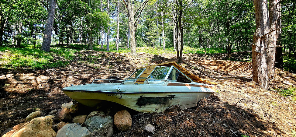
Overboard - .6 mile expert level gravity descent. This segment of trail provides the most challenge and sustained speed and elevation drop of any trail on the property. Riddled with jumps, rock gardens, big wooden features and steep descending grades this trail will challenge the most experienced rider while being built in a way that minimizes the potential of major injuries.
Connector Trails – .15 miles of beginner level connection trails that link several of the main loops together. There are two segments of connector trails built into the system. These trails allow users to interconnect different loops in a variety of different ways, allowing users that use the park regularly to have a fresh experience every time they venture out onto the trails.